Competition proposal. Hugo Lindberg, Martin Berg, Joar Nordvall, Anna Zander. (2023)
Tabula Non Rasa
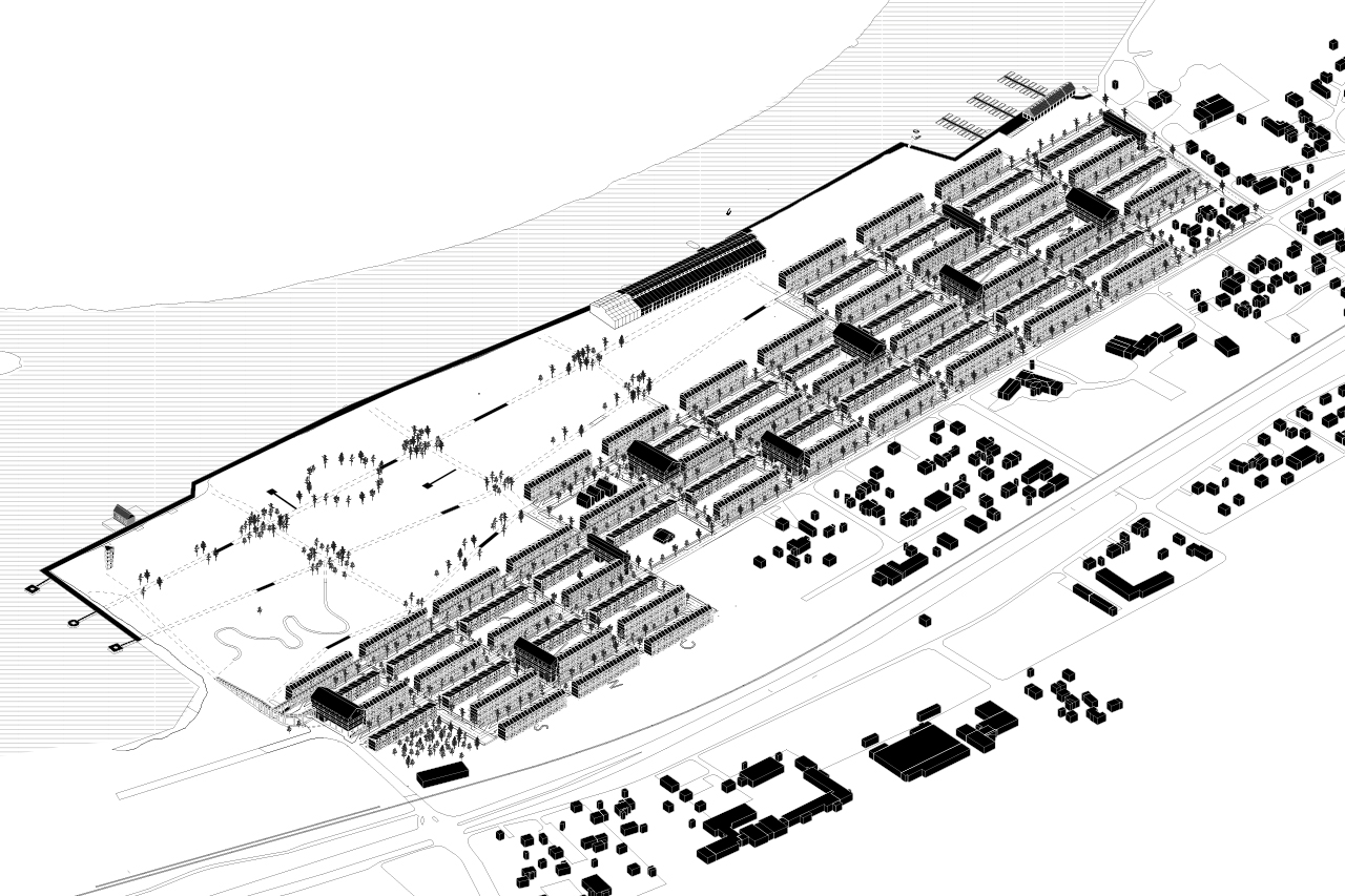
The Scharins area offers unique conditions in both a positive and challenging sense. Its history as an industrial site has contaminated the soil, resulting in a long clean-up project, and for years the site has been empty despite its fantastic location. But there is life. Ruderal vegetation such as birch trees have begun to reclaim the site as a whole and a small part on the western side is home to Camp Skellefteå Albatros 880, where construction workers and temporary employees of Northvolt’s battery factory live. While the arsenic and dioxin contamination poses challenges for land management, both birch trees and construction workers provide good conditions to quickly establish life on the site. Maintaining and respecting what exists is essential for the successful development of the area. However, building such a large park area as proposed from scratch risks being both time-consuming and costly. The young birches should therefore be seen as the first vegetation of the new park and the construction workers should be seen as the first inhabitants of the new residential area and in the creation of a new, vibrant neighborhood. Rapidly adding better housing for the construction workers should be seen as a top priority. The proposal draws lessons from the existing prefabricated housing modules, but is opposed to the low standards of 8.5 square meter homes that the construction workers now live in. Their new homes will be the first phase in the transformation of the Scharins area.
Underground infrastructure
moves above ground
The word Mjuklandning is Swedish for soft landing, which describes the proposal’s ambition to have as little impact as possible on the ground. In response to the contaminated soil and the need for rapid and cost-effective construction, the proposal has moved all the infrastructure above ground that is conventionally buried in the ground. Stormwater, water, sewer, district heating and cabled are all exposed. The top layer of the ground consists of new infill from the previous remediation process. In our proposal, this is sculpted to create a robust and beautiful open stormwater management system. Among the residential blocks, the paved streets become topographical high points from where rain and melt water flows down to the low points inside the residential courtyards. The courtyards are designed to handle large volumes of water, and a continuous stormwater channel runs between them. In an extreme 100-year rainfall event, the water level may overflow under the elevated houses. District heating, water and sewage pipes and cables are neatly laid under wooden walkways running east to west through the area, a kind of elevated wooden sidewalk. This makes them easily accessible for services without being too dominant in the cityscape. The pipes are properly insulated and extra heating cables prevent them from freezing in winter. The solution was inspired by the McMurdo research station in Antarctica. The resulting urban environment is reminiscent of the wooden sidewalks that once existed on the streets of Skellefteå. At the same time, they are innovative in a way that is in line with Skellefteå’s vision of being a city of the future where visionary ideas materialize. The new layer in the city that the visible infrastructure creates provides a new, educational dimension and becomes an integral part of the transition to a more sustainable society. This aspect is reinforced by an exhibition specific to the area that communicates the site’s history, new design and the progress of the site’s remediation. The exhibition will be located in the Hamnmagasinet.
The city block and the street
The urban plan consists of a strict grid forming streets and blocks. The street network extends several adjacent streets for a smooth connection to existing neighborhoods. The blocks are open and usually consist of two linear blocks (lamellhus) - one to the north and one to the south. House heights are adjusted so that they are lower in the south to allow for more sunlight in the courtyards. Main streets run from east to west while one-way local streets run from north to south. Parallel to the main streets are the wooden walkways located from which the entrance levels of the residential buildings are accessed. On one of the main streets there is also an elevated public walkway that runs through the entire area. It provides access to apartments, better connects the apartments with adjacent mobility hubs, and is part of a larger walking path in the area.
The 15-minute city
To enable the district to become a 15-minute city with sustainable modes of transport, mobility hubs are a crucial tool. They contain a wide range of common functions such as carpool, bicycle room, offices, nursery, garbage room, vertical communication etc. They have facades facing three streets and the fourth facade forms a backdrop to the residential courtyards. They are regularly found in the neighborhoods and are available in two sizes. The public elevated walkway also activates the mobility hubs on the upper level.
The park and the courtyards
The vegetation in the north, closest to the train tracks, is based on the existing forest landscape that is purposefully left untouched and where saved trees become the basis for the adjacent residential courtyards. In the south and the large park, ruderal plants, localized infill, and ground covers create smaller local contexts of vegetation. These wilder parts of the park are complemented by areas that are more landscaped, have good artificial lighting, etc. A third category of vegetation is along urban streets which are lined with trees flanked by tall grass and open residential courtyards. They help create interconnected green spaces that act as dispersal corridors for animals and plants.
The large park is located at the lowest part of the site and becomes a natural collection point for stormwater. A sealing layer of soil to prevent stormwater from flowing into the river is already in place. Stormwater is collected in depressions sculpted in the new infill of the ground. Depending on the season and weather, these may or may not be filled with water. Footpaths and bridges cross the landscape, dividing the park into zones containing different vegetation. Along the waterfront, an uninterrupted boardwalk is a natural continuation of the wooden sidewalks in the residential area, and the bridges in the park.
In some urban blocks, the soil in residential courtyards meet current health requirements, while others need further remediation. The solution we propose is to initially lift these courtyards onto a wooden deck in the same spirit as the wooden walkways on the streets. The wooden deck constitutes the common courtyard surface during the period of phytoremediation required to clean the top part of the soil to current standards. In addition to the purifying effect of the plants, they provide a beautiful setting surrounding the wooden deck. Pallet pots for cultivation and space for socializing create an attractive courtyard environment for the residents while the structure helps to communicate that the courtyard is undergoing a cleansing process. During this transition phase, we see that the municipality should have an active role in the measurement of pollution and maintenance of plants and decks. Residents and visitors can follow the progress of phytoremediation of the soil in the exhibition in Hamnmagasinet.
The Magnets
The residential buildings are given a matter-of-fact and rhythmic design without demanding very much visual attention. This makes them a good background for the public life in the streets and courtyards, and for the public buildings in the area. These public buildings become identity creating architectural elements and focal points in the area - we have chosen to call them Magnets. They are buildings such as mobility hubs, Hamnmagasinet, a bird watching tower, wooden jetties, windmill, water wheel, sauna, a train station and the elevated public walkway. Both as a resident and as a visitor to the area, the Magnets are a nice addition to the urban environment and contribute to a vibrant, living city. chosen to call them Magnets. They are buildings such as mobility hubs, Hamnmagasinet, a bird watching tower, wooden jetties, sauna, a train station and the elevated public walkway. Both as a resident and as a visitor to the area, the Magnets are a nice addition to the urban environment and contribute to a vibrant, living city.
Vernacular architecture
The name Mjuklandning, soft landing, also address the ambition of linking the new neighborhood to the area’s historical context. In developing the area, we have been inspired by vernacular architecture from both the site itself and from the region in general. One example of a specific reference on the site that we have used is Hamnmagasinet, which we propose on the site of the previous harbor warehouse - a kind of memory in physical form. It includes exhibition spaces, a plant nursery, a ticket hall for shuttle boats etc. Inspiration that is drawn from a more regional level includes the design of the mobility hubs. Characterful and expressive models have influenced this new building type and resulted in an architecture that is both forward-looking and site-specific. We also see that the construction with lightweight, wooden volume elements (volymelement) has an inherent connection to older residential buildings in the region. The individual volume element can be seen as the equivalent of the general room or the smallest component of former homes - the “fire cabin” (eldstugan). In the past, houses could be separated when two brothers grew up and needed their own separate yard. Rooms were gradually added and individual rooms could be accessed via a surface-mounted access balcony. Specific details, such as the fireplace and the outhouse, have also inspired the design of some of housing in the proposal.
The dwellings
The residential buildings made of volume elements are sustainable, cost-effective and quick to erect. The parts are transported by truck or boat and the volume element is adapted to go as ”wide load” on Swedish roads. The buildings are elevated on columns to reduce contact with the contaminated soil, allow for pipes and wiring underneath, and to allow storm water to flow from street to yard or overflow. Uninsulated roofs complete the houses to prevent excess heat from melting snow that has accumulated, while hiding the fan rooms on the roofs and integrating photovoltaic panels. The housing types cover a wide spectrum, ranging from small 35 sqm studio apartments to spacious terraced houses (radhus) on several levels. The dwellings have windows to both sides and are shallow, which provides good conditions for daylight. Access is made from the walkways on the entrance floor or from access balconies, generating a very efficient usage of heated space.
The proposal includes 148 000 sqm gross area (bruttoarea) for housing. The distribution of apartment types is highly flexible, and depending on the preferred mix the number of homes can vary between 1200 (only terrace houses) to 3000 (only studio apartments).